
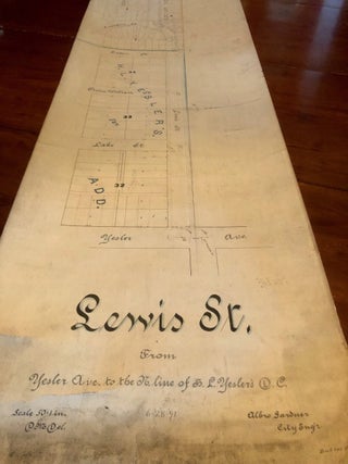
Map of Stillaguamish Mining District Snohomish Co. Washington Showing Property of the Deer Creek Gold & Copper Mining Co. [1897 original ink drawing]
Seattle: Anderson Map Company, 1897. Original manuscript. Loose sheet. 36 x 25 inches. India ink and color shading on drafting linen (Imperial Tracing Cloth.) Map scale 1000 feet to the inch. Edges minimally rubbed, light mellowed creases and soiling, left margin pierced for binding, short closed tear at left lower.....
![Item #5233 Index of Streets and Plans of Berlin [Plan of Berlin]. Karl BAEDEKER, Cartography -...](https://longbrosbooks.cdn.bibliopolis.com/pictures/5233.jpg?width=320&height=427&fit=bounds&auto=webp&v=1646002252)


![Item #6696 Brand Book II [2; Two] The San Diego Corral The Westerners. Jim DARLING, James Currie...](https://longbrosbooks.cdn.bibliopolis.com/pictures/6696.jpg?width=320&height=427&fit=bounds&auto=webp&v=1674698242)

![Item #7894 [WWII Infantry Route Map - Germany] 84th Infantry Division from Activation 15 October...](https://longbrosbooks.cdn.bibliopolis.com/pictures/7894.jpg?width=320&height=427&fit=bounds&auto=webp&v=1712040724)
![Item #11790 Spokane Washington [Color Birdseye View Map]. John W. Graham Company](https://longbrosbooks.cdn.bibliopolis.com/pictures/11790.jpg?width=320&height=427&fit=bounds&auto=webp&v=1768949440)
![Item #11502 Birdseye View of Puget Sound Country and Vicinity [1910 color illustrated map]....](https://longbrosbooks.cdn.bibliopolis.com/pictures/11502.jpeg?width=320&height=427&fit=bounds&auto=webp&v=1764366909)
![Item #7558 [Title Page:] King's Views of Brooklyn Made for the Lawyers Title Insurance Company ...](https://longbrosbooks.cdn.bibliopolis.com/pictures/7558.jpg?width=320&height=427&fit=bounds&auto=webp&v=1703380264)

![Item #11499 Standard Map of the Territory of Alaska [1925 original ink drawing]. Kroll Map Company](https://longbrosbooks.cdn.bibliopolis.com/pictures/11499.jpeg?width=320&height=427&fit=bounds&auto=webp&v=1764368566)
![Item #5322 Atlas of King Co. [Large Folio-size Plat Book of King County, Washington]. Kroll Map...](https://longbrosbooks.cdn.bibliopolis.com/pictures/5322.jpg?width=320&height=427&fit=bounds&auto=webp&v=1649028268)