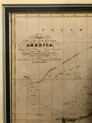
Chart of Part of the North West Coast of America, from Point Rodney to Point Barrow [Original FRAMED CHART]; in His Majesty's Ship Blossom assisted by Lieut. E. Belcher, Mr. T. Elsen, Master, M. Ja. Wolfe, Mate. AD 1826, 1827
London: Colburn & Bentley, 1831. First Edition. Framed under glass. Exposed chart measures 13" x 17 3/4". Hand-colored chart detailing part of the Bering (Beering) Strait and Kotzebue Sound. Expertly framed and matted. Old folds and a slight wrinkle, now flattened, off Point Hope, else Fine. Chart excised from BEECHEY.....
![Item #9831 Science and Civilisation [Civilization] in China Volume 1 Introductory Orientations....](https://longbrosbooks.cdn.bibliopolis.com/pictures/9831.jpg?width=320&height=427&fit=bounds&auto=webp&v=1742838027)
![Item #9832 Science and Civilisation [Civilization] in China Volume 2 History of Scientific...](https://longbrosbooks.cdn.bibliopolis.com/pictures/9832.jpg?width=320&height=427&fit=bounds&auto=webp&v=1742838833)
![Item #10673 Science and Civilisation [Civilization] in China Volume 5 - Chemistry and Chemical...](https://longbrosbooks.cdn.bibliopolis.com/pictures/10673.jpg?width=320&height=427&fit=bounds&auto=webp&v=1753759521)
![Item #10545 Science and Civilisation [Civilization] in China Volume 5 Chemistry and Chemical...](https://longbrosbooks.cdn.bibliopolis.com/pictures/10545.jpg?width=320&height=427&fit=bounds&auto=webp&v=1749836395)
